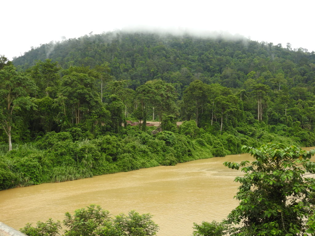
KUALA LUMPUR, Jan 18: At the height of devastating floods in several states in the recent months, that left many to seek shelter at relief centres, deforestation – a contributing factor for floods – also continued in the same states including in their primary forests, peat forests, intact forests and protected areas.
According to data from Global Forest Watch (GFW), Malaysia had a total of 76229 GLAD-L deforestation alerts (each Glad alert indicates alert indicates a 30 by 30 meter area – around the size of two basketball courts – that has experienced a disturbance in the forest canopy) for the period Jan 1 to 8 alone this year. These alerts covered a total of 5,900 thousand hectares in the affected areas in Peninsular Malaysia (and reviewed in this report).
In 2023, Malaysia, which houses the oldest rainforests in the world, was also among the top 10 countries in the world for high loss in tropical primary forest, losing 118,000 hectares of its natural forest, equivalent to 148 Mt of CO₂ emissions.
What do the continued loss of tropical forests in the country signify?
Tropical rainforests are important for their biodiversity, carbon storage and for regulating regional and local climate effects. Keeping these forests intact not only helps in the mitigation of climate change with their carbon sink role, but also helps in regulating temperatures, rainfall and healthy ecosystems. Losing them on the other hand will have repercussions in the long run and this could be anything from extreme weather patterns locally including heavier floods to increased air pollution, water pollution, zoonotic diseases, as well as loss in biodiversity, forest resources and displacement of people living close to these areas and increased conflicts between people and wild animals.
With all reasons to reduce deforestation, who are responsible for the forest clearings in these states, already affected by floods and getting aid from various factions including the Federal Government to fight the flood situation?
And why?
The lack of politcal will to address the real causes and put a stop to deforestation in low lying areas, where monsoon season brings severe devastation every year, is one reason, says conservationist, Andrew Sebastian, who is also CEO of Ecotourism & Conservation Society Malaysia (ECOMY).
“It is still shocking that several states that are annually hit by floodings are still unable to firstly appreciate and understand why the monsoonal season hits them hard and secondly how they can mitigate flooding even before the monsoon season starts,” Andrew told Weekly Echo in an interview.
Thirdly, they need to take stock of the most important factors which are contributing to such floodings, such as the conversion of forest for development of new housing areas, plantations, lack of control on logging, deforestation any where from Cameron Highlands to Gunung Stong, all of which affect the water systems and give rise to extreme floodings.
The various water basins and river systems are greatly stressed due to erosion and more sedimentation in the river. This happens because we have converted a lot of forests, opened up lands and put in new housing areas, and everything goes straight into the rivers, which are unable to take the load of siltation.
The states affected by the high tides and low tides in the low lying areas in the east coast, Pahang, which sees floodings in the deeper areas, upriver like in Taman Negara and Johor just being low lying — all these states already understand how the monsoon season will hit them and when.
The same happens every year like clockwork and yet every year again the states appear helpless with the Federal government having to aid, he said.
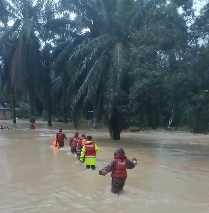
“Until and unless we get serious and talk about the root cause, which is the silting of rivers, the poor maintenance, where we are not clearing what we filled in the rivers – hydrological experts have been talking about this for years – and unless this is addressed, the floodings will continue and lives and properties will be lost.”
Based on data from GFW, from 2001 to 2023 Malaysia lost 2.95 million hectares of humid primary forest, making up 32% of its total tree cover loss in the same time period. Total area of humid primary forest in Malaysia decreased by 18 percent during this 22-year period. The country lost 9.23 million hectares of tree cover, equivalent to a 31% decrease in tree cover since 2000, and 5.32 Gt of CO₂e emissions.
The highest numbers were recorded during the years 2011 and 2014, which corresponded with devastating floods in Kelantan.
Another environmentalist said one reason for poor management of forests could be also to there being no standardised approach to forest management nationwide as land matters come under the jurisdiction of the respective states.
This may be a factor for the inconsistent and “impulsive” announcements related to plans for “land development”, which are usually tied to economic reasons, job opportunities. While some are essential development, but many are also unnecessary and the states must take the effort to consider the conservation of their forests, he said.
For states already in low lying areas, new development has resulted in floodings in areas that have never experienced floods before, he added.
Meanwhile, for the first week of 2025, Kelantan saw 4,827 deforestation alerts, covering a total of 59.15 hectares, including 15.5 hectares in primary forest. There was also encroachment of protected area.
Deforestation alerts in the area of Gua Musang, Kelantan covered close to 10 hectares of primary forest.
In Pahang, deforestation covered 1.2 thousand hectares during the first week of January, including in intact forest, primary forest and protected areas.
In Baling, Kedah, deforestation alerts covered 81 hectares covering intact forest, primary forest and protected area.
In Selangor, deforestation was detected in Hulu Langat, covering 20.22 hectares including 0.22 hectares of primary forest during the period.
There were also new areas of deforestation seen in Gua Musang, Kuala Krai, Jerantut, Chukai, Kuala Rompin as well as in Grik, Perak and Kuala Berang in Terengganu.
While deforestation alerts information collected via satellite images indicate forest clearing and loss of tree cover, their nature cannot be fuly determined such as whether they are caused by small-holder agriculture, commercial agriculture, mining or logging.
Forest rangers, surveyors, forest department officials and state authorities, including fire department officials when there are also fires in the same forests, would be able to determine the complete picture of what is happening on the ground. Some information can be also sourced when poachers and smugglers of protected animal species are caught and brought to courts.
Another environmentalist said one factor for inconsistencies in the management of forest is that forest land come under the state jurisdiction. Some states are reported to have been selling forest land for planting. “One state has reportedly sold land to political party members, who admitted that it was not easy to “clear the difficult terrains of these forest areas” to do any work.”
With climate change and the committment to net zero carbon emission, keeping these areas can be economic move too. Malaysia has to move several degrees away from its dependency of the exports of commodities for which lands are cleared, as well as other forest products unless their sustainability is guaranteed.
He also said the country was already moving into new areas of economy and hence it could go easier on businesses that rely on forest products that despite sustainable practices, will see depletion in the long run.
There are many regulations that protect our forests, but sometimes the circumventing of laws also take place to enable the encroachment of forest areas, he said.
— WE